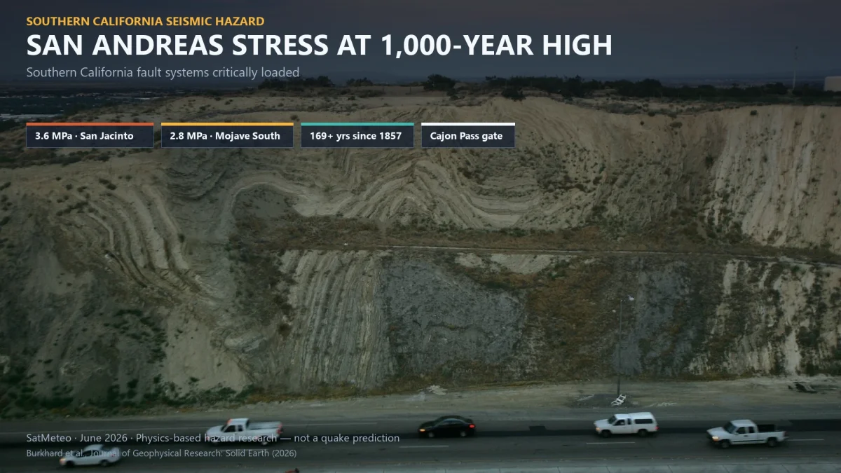
Tectonic stress along Southern California's San Andreas and San Jacinto fault systems has reached — and in some places exceeded — the highest levels seen in the past 1,000 years, according to new research led by geophysicist Liliane Burkhard of the University of Bern and the University of Hawaiʻi at Mānoa. The peer-reviewed study, published 3 June 2026 in the Journal of Geophysical Research: Solid Earth, does not predict when the next major earthquake will strike. Instead, it quantifies how much mechanical stress has built up across one of America's most densely populated seismic corridors — and why a junction called Cajon Pass could shape whether the next large rupture stays on one fault or crosses both systems at once.
What the model found
Burkhard and colleagues from the U.S. Geological Survey Earthquake Science Center in Pasadena and the Scripps Institution of Oceanography at UC San Diego built a physics-based, four-dimensional earthquake cycle model — three spatial dimensions plus time — and fed it a millennium of Southern California rupture history reconstructed from radiocarbon dating of displaced sediments, tree-ring anomalies, and documented surface breaks.
The simulation tracks how each earthquake redistributes stress on neighbouring segments, how locked faults reload during quiet centuries, and how deeper crustal layers slowly relax after large events. Running that history forward to the present day, the team estimates the fault system is now in what Burkhard calls a "critically loaded state."
On the San Jacinto–Bernardino segment, modeled stress stands at 3.6 MPa — above the prior millennium peak of 2.9 MPa recorded just before a 1249 rupture on the same section, roughly 24% higher. On the neighbouring Mojave South section of the San Andreas, stress has reached 2.8 MPa, also the highest value in the entire 1,000-year simulation. Burkhard told reporters the significance lies not in the number alone but in the scale: fault planes here extend tens of kilometres along strike and to depths of 10–20 km (6–12 miles), so energy released when locked rock fails scales with both stress and rupture area.
169 years since the last major southern rupture
The southern San Andreas has not produced a major rupture since the 1857 Fort Tejon earthquake, estimated at magnitude 7.9 — still the most powerful event on that section in recorded California history. That quiet interval now spans 169 years, during which steady Pacific–North American plate motion has continued loading locked fault surfaces without a large release.
"Right now, with stress at historically high levels across the region and more than 160 years elapsed since the last major rupture, the system is in a critically loaded state," Burkhard said in a University of Hawaiʻi press release.
The San Andreas forms the primary boundary between the Pacific and North American plates, running roughly 1,050 km (650 miles) through much of California as a strike-slip system — meaning the plates slide horizontally past one another rather than pulling apart. Even in a very large earthquake, what moves is sideways displacement along the fault trace, not a breakup of the landmass.
Cajon Pass: the "earthquake gate"
Northeast of Los Angeles, where the San Andreas and San Jacinto systems converge, lies Cajon Pass — a rugged gap through the Transverse Ranges where Interstate 15, freight rail, and energy infrastructure funnel through a geologically critical junction. The study introduces Cajon Pass as an "earthquake gate": a point that can either arrest a rupture at the intersection or allow it to propagate across both fault networks in a single through-going event.
Historical examples illustrate both behaviours. The 1857 Fort Tejon earthquake terminated at Cajon Pass, confining damage primarily to the San Andreas. The 1812 Wrightwood earthquake crossed the junction, rupturing both systems simultaneously. The decisive factor, the model suggests, is not only how much stress has built on each fault individually but how aligned stress levels on the two systems are at the moment of failure. When both rise in concert toward similarly high values — as they have now — conditions favour cross-fault propagation.
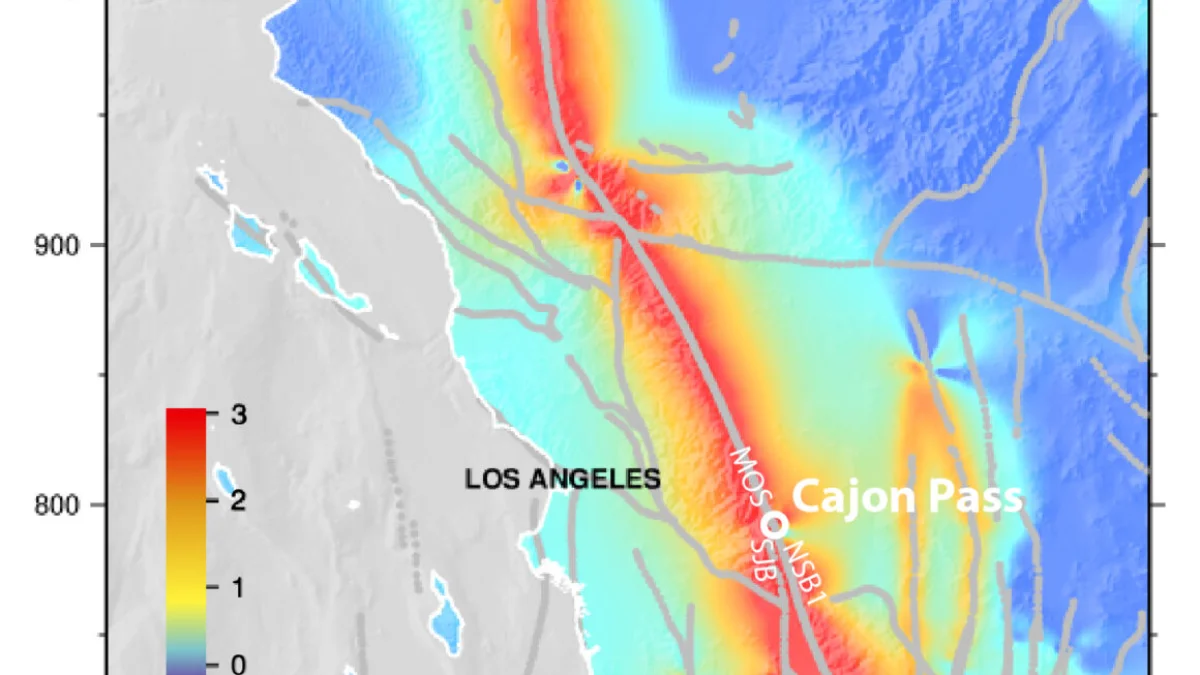
"Not only is it concerning that the stresses are reaching historic highs," Burkhard said, "but also that the relative stress conditions between the two fault systems are approaching the range we associate with major ruptures crossing both faults simultaneously — and that is a scenario with much larger consequences for the region."
Who faces elevated exposure
A joint rupture crossing Cajon Pass would affect some of the most populated and infrastructure-critical corridors in the United States — including the greater Los Angeles basin, San Bernardino, Riverside, and the Palm Springs / Coachella Valley region served by the southern San Andreas and San Jacinto systems.
For planning context only — not as a forecast — the USGS ShakeOut scenario models a magnitude 7.8 rupture on the southern San Andreas alone and estimates roughly 1,800 deaths, 50,000 injuries, and about $200 billion in direct damage. A cross-fault event involving both systems would be substantially larger than that baseline. The last comparable through-going rupture in the modelled record was the 1812 Wrightwood earthquake.
Major highways, railroads, water and power lines run directly through Cajon Pass itself, making the junction a logistical chokepoint as well as a tectonic one. Burkhard emphasises the findings are inputs to seismic hazard assessment — the technical process behind building codes, infrastructure design, and emergency planning — rather than a countdown clock.
What science can and cannot say
Earthquake timing remains impossible to predict. Neither the USGS nor academic researchers issue short-term forecasts of major California earthquakes, and Burkhard states plainly: "This is not a prediction of when an earthquake will happen." What physics-based models can establish is the current mechanical loading state and the range of rupture scenarios for which planners should prepare.
The study's stress figures post-date California's latest building-code cycle, which took effect 1 January 2026 under updated ASCE 7-22 seismic maps. Burkhard's results could inform the next revision of the USGS National Seismic Hazard Model, which underpins those standards.
Burkhard and colleagues also developed LA-GRID, a public web tool visualising seismicity, fault traces, and critical infrastructure across the Los Angeles region with live updates on earthquakes and wildfires.
Preparedness for Southern California residents
Official guidance at earthquake.ca.gov urges residents in affected areas to prepare for sudden shaking with no warning: secure heavy furniture, know how to Drop, Cover, and Hold On, maintain at least 72 hours of emergency supplies, review earthquake insurance, and establish a household communication plan. California's Earthquake Early Warning system can deliver seconds of notice via Wireless Emergency Alerts, Android Earthquake Alerts, or the MyShake app before the strongest shaking arrives — though alerts may arrive only as shaking begins for those nearest the epicentre.
Track Southern California conditions on SatMeteo
While earthquake science cannot forecast rupture dates, weather and environmental conditions shape daily life across the corridors this study highlights. Follow forecasts for Los Angeles, San Bernardino, Riverside, and Palm Springs, and use the live temperature map to monitor conditions across Southern California in real time.