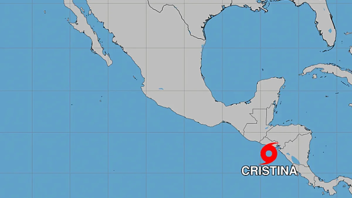
Tropical Storm Cristina is delivering days of heavy Pacific rainfall, gusty onshore winds and a rising flood threat across Central America. The third named storm of the 2026 eastern Pacific season formed on Monday and has since drifted slowly near the coast, with sustained winds near 65 km/h (40 mph) and a forecast path that hugs Nicaragua, Honduras and El Salvador before weakening midweek. Even as peak winds fade, the meteorological story is water: widespread totals of 100–200 mm (4–8 inches), locally up to 300 mm (12 inches), and saturated soils that raise the risk of mudslides in steep terrain.
Where Cristina is and how it is moving
The U.S. National Hurricane Center placed Cristina roughly 150 km (93 mi) west-northwest of Managua on 9 June, moving north or north-northeast at only about 6 km/h (4 mph). That slow, coast-hugging motion keeps onshore flow pointed at the same stretch of shoreline for days, prolonging rainfall rather than sweeping the storm quickly out to sea.
Forecasters expect Cristina to meander along the Central American Pacific coast through midweek, approaching the southern Gulf of Fonseca near El Salvador before gradually turning northwestward into the open Pacific. The system may weaken back to a tropical depression by Wednesday and dissipate by Thursday, but heavy rain is expected to continue across the region through at least Thursday morning. Tropical storm warnings were in effect from Puerto Sandino in Nicaragua to the Guatemala–El Salvador border.
Rainfall forecast and why the hazard is flooding
The primary threat is not wind speed but accumulated rain on already wet ground. The NHC warned that Cristina could produce life-threatening flash flooding and mudslides, especially on steep slopes, with coastal flooding from storm surge possible where winds blow onshore. Central America ranks among the world's most hurricane-prone regions, and eastern Pacific systems that scrape the coast often cause their worst impacts through prolonged downpours.
Remnant moisture from Tropical Storm Boris — which weakened to a depression over southern Mexico earlier in the week — had already spread cloudiness and rain across parts of the isthmus, potentially compounding runoff as Cristina's bands move through. Sea-surface temperatures in the eastern Pacific remain above average for June, consistent with an active start to the basin's season; the first named storm typically forms around 10 June.
El Salvador: orange alert, shelters and closed ports
El Salvador remained under an orange alert as Cristina neared the southern Gulf of Fonseca. The education ministry closed schools and universities on 9 and 10 June because of landslide and flooding risks. Civil protection officials said more than 150 mm (6 in) could fall over three days, accompanied by gusts to about 70 km/h (43 mph).
At La Libertad, 35 km (21.7 mi) south of San Salvador, fishermen were ordered to remain in port as strong waves lashed the shoreline. Dozens of seafront shops and the seafood market shuttered ahead of the storm. Civil protection director Luis Alonso Amaya said 180 shelters were prepared nationwide for families who may need to leave flood-prone barrios and hillsides.
Nicaragua, Honduras and Guatemala
In Nicaragua, co-president Rosario Murillo urged residents to stay away from the coast as rains intensified from Sunday onward. Rough seas and persistent rainfall stranded small boats on beaches and flooded low-lying coastal areas. Maritime activity was suspended in several ports because of hazardous wave conditions.
Honduras issued alerts across nine regions as emergency teams prepared for swollen rivers and saturated hillsides. In Guatemala City, disaster coordinators warned that the heaviest rainfall would concentrate along the Pacific coast, the central Altiplano and eastern valleys, with risks of river flooding, sudden flash floods and lahars on volcanoes Fuego and Santiaguito.
Costa Rica: rough seas, alerts and missing fishermen
Cristina's influence extended south into Costa Rica even though the centre remained north of the border. The National Emergency Commission reported five people missing after two small boats capsized in heavy surf off Playa Negra and Tamarindo in Guanacaste. Search teams faced high-risk conditions and urged fishermen not to put to sea.
Costa Rica maintained a yellow alert — the middle tier of its three-level system — for the Central Valley and entire Pacific slope, with a green alert for the Northern Zone and Caribbean. The meteorological institute forecast wet conditions through at least 10 June, with the heaviest rain on the North and Central Pacific and frequent showers in the Central Valley. Nine schools in Nicoya closed after fallen trees blocked access roads, and officials reported structural damage in Bahía Drake on the Osa Peninsula.
What to watch through Thursday
Hourly rainfall rates, not just daily totals, will determine where rivers breach and hillsides fail. Slow-moving showers embedded in Cristina's outer bands can train over the same watersheds for hours. Residents in Pacific coastal departments, volcanic foothills and urban flood zones should monitor official advisories, avoid crossing swollen rivers, and treat rough seas and rip currents as ongoing hazards even after winds drop.
Track Cristina weather on SatMeteo
Flood and mudslide risk will shift with local terrain and each passing rain band. Check hourly forecasts for Managua, San Salvador, Guatemala City, Tegucigalpa and San José on SatMeteo, and use the temperature map to monitor broader weather patterns across Central America and the eastern Pacific.